
Trail and Ale - Fox and Hounds
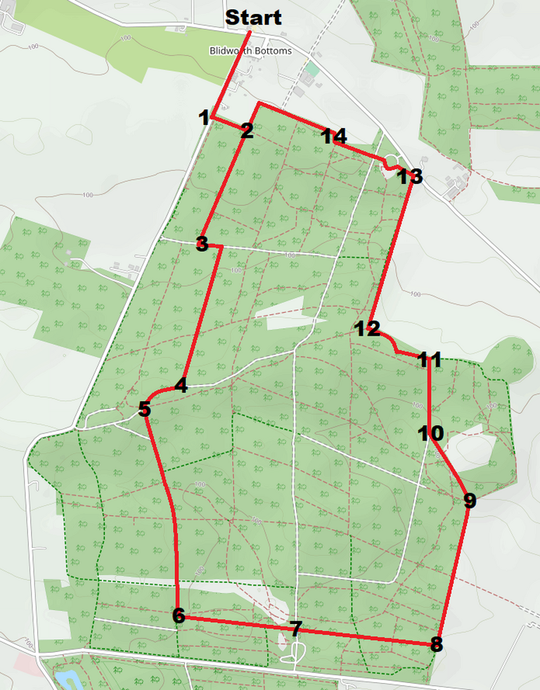
Length - 6.75 km (4.2 miles) Ascent - 105m (870ft) Terrain - A short section of roadway, well-made tracks and woodland footpaths. No stiles. Map: Explorer270 Address: Calverton Rd, Blidworth Bottoms, Nottingham NG21 0NW.
In this issue, I venture out to the southern end of the branch for a shady woodland walk that’s perfect in the summer months when the mercury is rising. The illustrated four miles follows some of the wider, gravelled tracks through the wood for ease of direction. However, there are so many paths that criss-cross - you could shorten or lengthen the walk as you see fit, or stick to the quieter woodland footpaths instead. On a sunny, warm Saturday afternoon I passed only a handful of people - mostly near to the Longdale Lane car park where there are picnic tables and sometimes a catering wagon - leaving the rest of the walk to just me, Duggie and the birds. Expect uniform rows of evergreens standing tall over oak, chestnut and ash, and plenty of birdsong.
Route - From the pub, cross the road and head up Rigg Lane. After 350m, as the road levels out, turn left into the woods where provision has been made to do so (1). Follow the path 120m to a junction and turn right (2). Continue along this path for 450m until it ends at a TJunction and turn left (3). (You can mostly avoid the mud here by taking the path to the left just as you reach the end cutting the corner). Take the next right after 100m and head up the long incline. After another 550m the path levels out at a T-Junction (4), turn right and follow the track as it curves slightly to the left. At the next junction in the track (5), take a left and head slightly downhill with the clearing to your right. Stay on this track for 800m ignoring all side paths until the track turns to the left (6). Stay on the track, heading east, for 450m until it joins another track leading from the car park (7). Go straight ahead onto a smaller footpath, through a squeezer and past the pylon, then continue for another 500m to the edge of the wood (8). Turn left and head north, along the edge of the wood for 550m. At a junction of paths (9), pass to the right of the ‘Horse riding by permit only sign’ and head north-west for 280m. Turn slightly right as a path joins from the left beside a clearing (10) and head north uphill to the edge of the wood (11). Turn left and follow the path along the edge of the wood, turning right after 250m (12). With the edge of the wood still on your right, continue downhill for almost 600m until you almost reach Calverton road (13). Turn left and walk through the car park, taking the path on the opposite side. Follow this through the junction keeping the edge of the wood to your right as it turns slightly right then left again (14). After 300m the path turns left - follow this for 100m until it arrives at a junction (2). Turn right and follow this back to Rigg Lane (1). Turn right and head back down the road to the Fox and Hounds.